Luddenden, Booth & Midgley
3.5 miles – 2 hours – grade 2
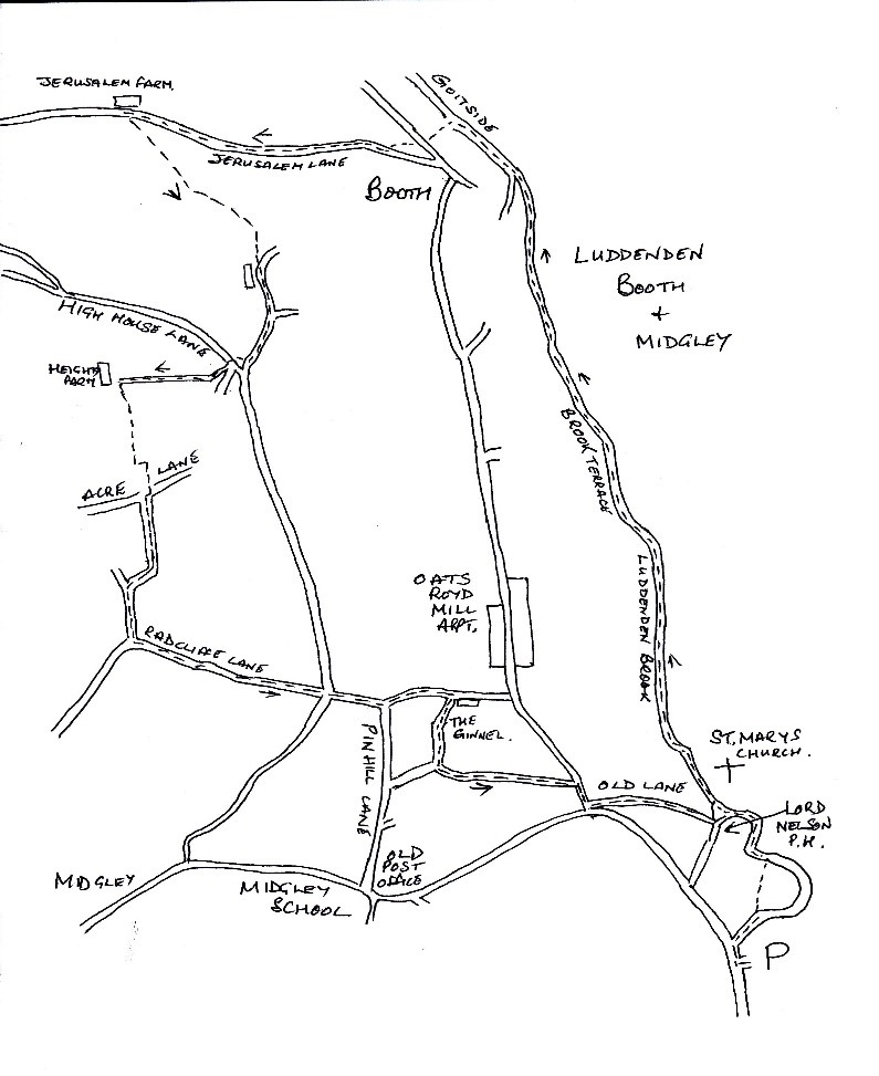
The walk starts from the public carpark on Luddenden Lane, go past Kershaw House and the carpark is on the right.
Leave the carpark and turn right, at the junction take the right-hand fork and walk down, passing Bluebell Way. The road turns to the right, go straight forward in front of the houses, you will see a sign post on the wall saying footpath to the Lord Nelson; just after the houses you will come to a cobbled path, at the end turn left and follow the small road between the houses.
St. Mary’s Church will face you, walk into the church yard and follow the path to the left, you will see a bridge, leading into the graveyard, on the left before the bridge you will see the footpath which follows the side of the Luddenden Brook.
Follow this path, you will see to your left on the hill top the Oats Royd Mill Apartments, the path passes several rows of old mill cottages, the first being Brook Terrace. Further along the track you will come to Goitside.
Opposite the cottages on the left is a path uphill, the old graveyard from the former United Reform Chapel can be seen on the left. Climb the steps and cross the tarmac road to the stepped stile, this climbs uphill on to Jerusalem Lane.
Walk to the right along this tarmac road until you reach Jerusalem Farm, the Countryside Service Education and Training Centre; one of the countries favorite camping sites.
Opposite the farm the footpath enters the field and heads uphill to the left. Go through the wall and follow this path. Its diagonal route across the fields is easy to follow. Eventually a row of farm cottages with a cobbled yard is reached. Go past the houses and along the gravel surfaced track.
Look out for a set of steps in the tall retaining wall to your right, just before you come to the junction ahead. Take this route. Climb the steps which emerge onto the road and across to the corner of the row of cottages opposite. The footpath goes behind the cottages and follows the wall uphill.
After crossing the fields, Heights Farm is reached, turn left here after going through the gate. The path follows the wall for quite a way, going over several styles, bringing you to a small gate and eventually a walled lane, the Old Acre Lane, leading up to the moors is reached.
Turn left to go down Old Acre Lane and you will see on your right a signpost and gate, this will take you in front of the farm house, continue following the line of the wall. You will come to a style at the far end of the field, turn left and continue along the path. At the next track turn right through the gate and head up the concrete road. Follow this road past the houses, it bears left and then goes downhill. The straight tarmac road is called Radcliffe Lane.
At the crossroads go straight across down the cobbled lane. You will come to a tarmac road, straight forward you will see a cobbled path going down the hillside. Follow this path until you come to a row of cottages on the right.
Turn right at the corner of the row of cottages on to a walled path called The Ginnel. Follow this narrow pathway until a gated gap on the left in the ginnel wall is reached. Turn left through this gap and follow the stone steps down into the field. The path goes diagonally to the right for a few meters and then follows the line of the telegraph poles down to a style. You will see in front of you a small fenced square, walk to the right of the square, you will see to your left another style in the corner of the fencing.
Go over the stile which will bring you onto the road to Booth. Turn right and walk to the junction with the main road. Turn sharp left down a cobbled track called Old Lane. At the bottom turn left and you will come back to the church and the Lord Nelson PH. Retrace your steps back between the houses and along the cobbled path to the carpark.