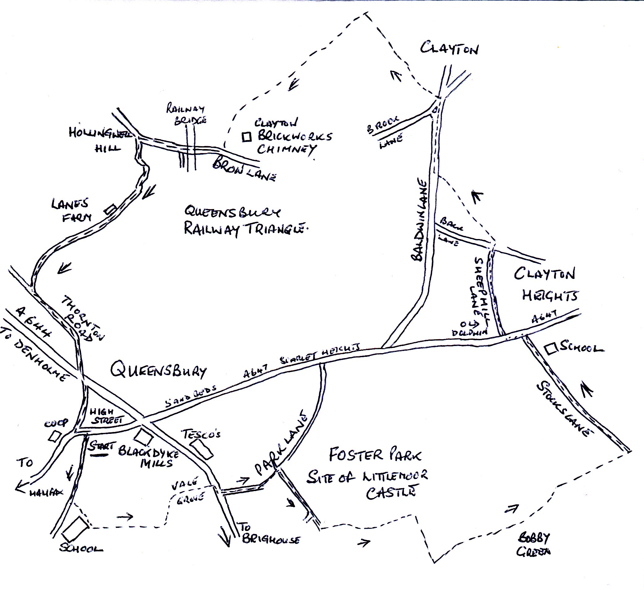
Around the Triangle
4.5 miles – 2.5 hours – grade 2
Our walk starts on the High Street in Queensbury, there is plenty of on street parking. With the CO-OP to your right, the first set of shops to your left, cross the road to find a cobbled path between the shop and house, the path will shortly become a fenced path with the new housing development on your left and the cemetery on your right.
Continue along the path to the end of the houses, a tarmac path is to your left, this will soon become a dirt track. A stone gap will lead you into the field on your left, continue down the field to the left-hand corner, you will see some steps taking you around the large stone wall.
Keep left, the path is often overgrown, you will enter the top of Vale Grove, an unmade road. Walk to the bottom, cross the road and turn right, you will walk to the junction with Park Road, turn left and walk down the road, there are no footpaths, so be very aware of the two-way traffic. Opposite the entrance to Park House Nursing Home, you will see the track, New House Lane, continue down the track to the large gate at the bottom.
To your left is Foster Park, once the home of the Fosters of Black Dyke Mills, the remains of their home remains, it was called Littlemoor and after many alterations over the years was called Littlemoor Castle; in 1937 the house and grounds were bequeathed to the people of Queensbury.
On the left-hand side of the gate is a gap, leading on to a fenced path. At the end of the path and the many junctions, turn right into the field, the path goes along the top of the field to a gated style in the far left-hand corner. This will lead you onto a wide dirt track, turn left and walk up to the farm on your right – Bobby Green.
Just past the junction on your left, you will see a stone step style into the field, to your right you will see the well-defined paths leading you through the fields to Stocks Lane. Turn left and walk up the track, passing the school on your right and the War Memorial at the top, on your left.
Cross the road and turn left, you will see the signpost for Sheep Hill Lane, this soon becomes a walled track leading you behind the houses with the valley to your left. You will come out onto Back Lane, opposite you will see the sign for the Bronte Way, which leads you down through the fields to Baldwin Lane. (if cattle are grazing, you can always walk down Back Lane to Baldwin Lane, turn right and head towards Clayton).
On approaching the start of Clayton, you will cross Broomfield Place on your left and then Brook Lane, take the next turning left, at the back of No. 2 Brook Lane. This is the continuation of The Bronte Way, follow the walled track behind the houses to a stone style. Continue straight down the field to another style in the far left-hand corner, once through, on your left is another stone gap style, the path goes forward to a broken wall and on towards a small tree. Keep to the right-hand side of the tree and you will see in the middle of the far wall a style.
A well-defined path with now take you along the valley bottom, a long row of conifers growing in the bottom, with the spoil heap to your left. If you look to your left, after the spoil heap you can see the observatory on the top of the house of Mr. Julis Whitehead of Clayton Fireclay Brickworks and near to this the mill chimney.
The chimney was built in a single day in 1908 by his son Claude, the later decorations of the cup, were added in 1911 to commemorate Bradford FC winning the FA Cup; the new cup was incidentally made in Bradford by the jewels Fatorini.
The path comes out onto Brow Lane, turn right and walk up and under the railway viaduct. On your left you will reach the cottages at Hollingwell Hill, turn left in front of the houses to walk down Bridle Stile Lane, next to the garage. The track starts to climb up to Lanes Farm and becomes a tarmac road going up the valley to join Thornton Road. Turn left and walk up the hill to the crossroad, walk straight forward on to Chapel Street and back to the High Street.

