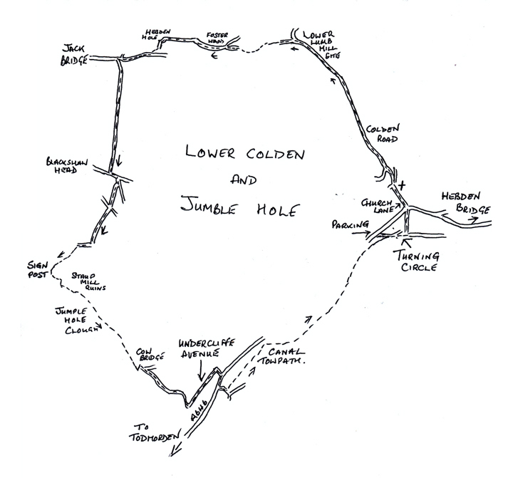
There are several places to park in Hebden Bridge, the walk starts from the turning circle, where there is a lay-by opposite.
You will pass several ruins of old mills along the walk; it is very difficult to imagine how big some of them were. They operated in the early 1800’s and spun cotton or were die houses, using the water from the river and streams.
You will walk towards Hebden Bridge, on the left is Church Lane, pass the church and the school and continue up the steep road. The road turns sharp left but carry on to the right along a track, Colden Road. Carry along this road, after passing a block of houses the road forks, take the right-hand fork and continue until you reach the first mill site – Lower Lumb Mill – which spanned the river.
At the bridge keep to the left, as you walk forward on to another old mill site, you will see to your right a low arch and pits in the far-right corner. Go up the steps, then forward rising a little. You will join the old mill dam embankment about 100 meters ahead. Follow it along the left-hand side of the dams.
At the end of the old dam, you go down one step to the riverside, forward only for 6 meters, then turn right up the side of more mill ruins. Turn right at the top of this path, then left on to a path along the hillside, this then becomes a wide track.
Where the track doubles back to the right, go straight forward on to a woodland path, which rises steadily. When it forks, take the right-hand path up to the far top corner of this wood.
Continue forward on the causey path to Hebden Hole Bridge; you will walk past the Praying Hole; John Wesley addressed many hundreds of people here on his travels. Crossing the bridge, the path takes you up the steps on to a lane. Turn right and follow the lane for about 300 meters, turn into the first lane on the left.
Follow the lane past the end of the house and straight uphill, following the walled path over the high point and descending to the road.
Turn left, about 50 meters on the right is Marsh Lane and then right again on to a grassy lane. Follow this down the slope to pass between two farmsteads, continue straight ahead.
At the next style, turn right along the wall side, which bears left and leads to another style. Forward in the same line across the next open field aiming at the stile and signpost. Alternately you can carry straight forward to the hill side and turn right to bring you to the stile and signpost, if animals are in the field.
From the wall stile, turn half left and descend the slope. A path line soon emerges leading to a bridge and the Jumble Hole Beck. Over the bridge, turn left and follow the path to the ruins of Staups Mill. Veer slightly right up an old track and after 20 meters, go through the stile on the left.
This path is narrow initially on the steep hillside but widens as it descends the clough. At a ‘z’ bend you come to Cow Bridge, the site of another former mill. The lane is now quite substantial and continues down the streamside, you will pass the site of Spa Mill on to Underbank Mill. You will approach the railway bridge, turn left and walk along Underbank Avenue.
Walk along the avenue to the other railway bridge and on to the main road; turn right for 80 meters and cross the road, going over the river bridge. Just before the canal bridge, turn left and join the towpath. Follow this back to Hebden Bridge. You can leave the towpath just after the Stubbings Wharf PH our continue under the bridge ahead and take the next left, to bring you out opposite Church Lane.

