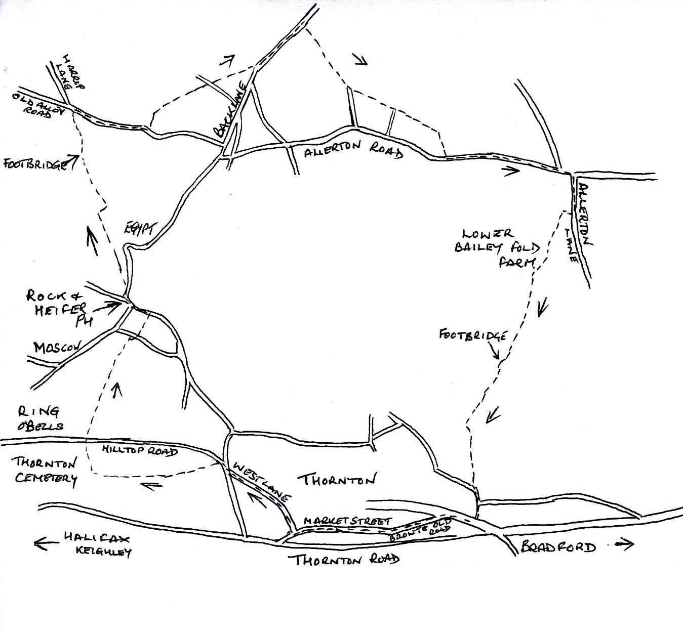
We start our walk on Hill Top Road, Thornton, near to the Ring O’ Bells Public House, there is ample parking on the road.
Walk past the pub and on your left, you will find an old wrought iron gate, the path will lead you between the houses on a stone path and out into a field. Keep the wall on your right and follow the well-defined path to the bottom right-hand corner and into a short narrow fenced path, you will climb a style and then down a short incline to another style, continue straightforward on the fenced path, you will climb two more styles and eventually enter another field.
The footpath through the field bears slightly right on the top edge of a deep gully, the path leading downhill to a field gate. The gap is on your right-hand side and out onto Upper Heights Road. Cross the road and you will see a style in the fence next to the field gate. Keep the fence on your left and walk straight down the field to a style in the left-hand corner, this will bring you onto Lower Heights Road.
Turn left and walk towards the Rock and Heifer Inn, at the junction turn right down Egypt Road. After approximately 140 meters you will find a field marker on your left leading you through a narrow gap and up a few steps onto a walled footpath. Climb the style next to the field gate to follow the partially paved stone path across the field, keeping close to the dry stone wall on your left, as it bears left to go through a narrow gap in the next dry stone wall.
Here cross a rough field track and continue straight ahead, again keeping close to the dry-stone wall on your left and over another style to continue along following the dry-stone wall on your left to a second style, as you start to drop down to a small hamlet which can be seen in the distance. On nearing the hamlet of High Stream Head at the bottom of a flight of steps, the footpath turns sharp right and over a style passing the ornamental gates on your left before joining the surfaced driveway in front of the row of cottages at Upper Stream Head.
Here turn right along the drive following it as it bears left uphill to a small gate at the right-hand side of the building. Go through the gate onto a small rough surfaced parking area to continue straight ahead the short distance to a second gate near the gable end of the next buildings at High Stream Head.
Once through the gate and in the field the path follows the gable end wall of the house gently uphill for approx. 24 meters, here the path bears to the right diagonally downhill to follow an obvious wide level grass path leading down to a gateway through the drystone wall ahead. Through the gap, again cross the next field diagonally to the right heading for a narrow squeeze style below the houses at Low Stream Head which can be seen ahead.
Climb the style into a narrow-walled path, immediately crossing a small bridge and over Pitty Beck, before walking uphill through the metal gates between the house and the kennels and out onto a wide dirt road, Stream Head Road. Here walk up the road to its junction at the top with Old Allen Road. Turn right wo walk up Old Allen Road, passing Hill View, a bungalow on your right and continue up the road a short distance to Little Moortop Far. Here walk just beyond the buildings of the farm and look out for a style in the dry stone wall on you left, go through the style into the field to follow the footpath along the farms perimeter dry stone wall on your left.
After a short distance the wall ends, here continue by walking diagonally to the left towards the style, which you will see in the dry-stone wall ahead. Once over the style into the next field continue by walking straight ahead and over the broken-down stone wall, where the next style should be to continue straight ahead again over the next field to another style at the right-hand side from the farm gateway. Once over this style continue walking straight ahead following the dry-stone wall on your left and through another style onto a farm track.
Follow the farm track again straight ahead, eventually to go through a style next to a gate and out onto Stevenson Road. Follow the road to its junction with Back Lane and turn left here to walk down Back Lane for about 275 meters. On your right you will see a style in the dry-stone wall, follow the footpath up the incline to the dry-stone wall on your right. At the top of the incline where the field levels out, cross an obvious field track and continue straight ahead towards the wide gap in the dry-stone wall, keeping the wall on your right.
Go through the gap in the wall and continue straight ahead across the next field a short distance until you reach the broken-down dry-stone wall in the top left-hand corner of the field. Here climb over the broken-down wall where the style should be and continue by walking with the wall on your left, as you turn left following the wall across the field to the next style. Once over the style continue to follow the wall on your left across the next field to another style in the wall corner of the rear of the farm buildings of Shay House Farm, to walk along a narrow walled path to emerge out onto the farm access track. Cross the track straight ahead you will see a large stone style leading you onto a fence path with the barn to your right. You will go over another style into the field, keeping to the left, cross the field to a style which leads you onto a fence path around the white house and up the path by the side of the house onto a track. Follow the track, passing the houses on your left, the track will turn sharp right, on your left you will see a metal gate leading you into the field. Follow the path on your right and through the two fields and onto a grassy walled path ahead. You will come to a T junction of paths, turn right and follow the path until you reach Allerton Road.
Turn left and walk along Allerton Road for quite some distance, on your right you will come to Cote Lane, turn down here, passing the houses on your right, you will come to a narrow road leading to Bailey Fold. Follow this road down the hill and passing the houses and stables, you will see in front of you a metal field gate. Continue down the field, with the stone wall on your left and pass through two more gates. Just after the last gate the wall finishes, bear right here to follow the line of trees on your right, as you continue downhill to the bottom of the valley. You will come to a flat stone bridge crossing Pitty Beck.
After crossing the bridge bear to your left to walk the 45 meters to the style in the stone wall. Go straight ahead uphill following the dry-stone wall on your left to go through a second style halfway up, eventually reaching a style next to the gateway at the top. Turn left through the style and follow the wall on your right to a second gateway with a style, the footpath joins a grassy track here leading you through the hamlet of Upper Hoyle Ings and out onto Northcliffe Lane. Follow the land downhill to its junction with Spring Head Road, turn right to walk along Spring Head Road before taking the second turning on the left to walk along Bronte Old Road, you will continue along Market Street and into the heart of the village.
You are obviously in the heart of the Bronte’s and as you walk along Market Street you will see the house where Charlotte, Patrick, Emily Jane and Anne were born. If you have the time to see the remains of the Old Bell Chapel, it is across the main road from the church. It was often called the Bronte Bell Chapel because the Rev. Patrick Bronte had it rebuilt along with a bell tower.
When you continue walking along Market Street, before it drops down to the main road, on your right is West Lane. Walk up West Lane to its junction with the top of James Street, cross over to walk along the road opposite, Reservoir View. At the end of the road go through the gap in the stone wall and continue by walking straight ahead following the well-worn path along the hillside. Climbing several styles and crossing fields until you reach the rusty metal railing and kissing gate at the entrance to Thornton Cemetery.
Do not go through the gate into the cemetery but turn sharp right uphill through the gap in the stone wall, keeping close to the trees and fence on your left continue to the top edge of the field. Go through the style and cross the dirt track, continue up the narrow path to emerge onto Hill Top Road, with the Ring O’ Bells to your left.
You can always plan your walk to enable you to sample the fine ales and excellent food at either the Ring O’ Bells Public House or the White Horse Inn afterwards!