10 stile – ‘wow factor’ panorama, on good day!
Circular clockwise
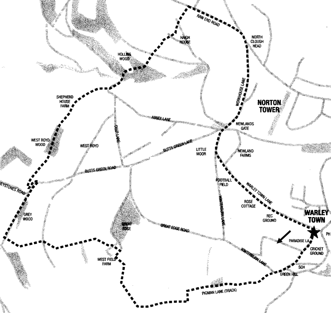
Start: Warley, HX2 7RZ
Go on path between chapel and playground car park ie on Paradise Lane towards School*. Pass school and go down right, to road junction.
* alternative:
Just before school, go right along track between allotments. Then through cemetery and left down to road. Go right up for approx. 75 yards then left over stile into field. Go down to meet green lane, turn right.
Panoramic views of Sowerby Bridge, Norland, Sowerby and Boulderclough.
Turn right for 50 yards and then left onto green lane. Go down and ahead over stile until sharp right-angle left turn. Go down a short distance to reach signpost and turn right, through gate.
Go along top of field with wall on right. After gate in wall, angle right up field and through a kissing gate in top left corner.
Go through and up field with wall on left. At large sycamore tree, go left, over stile and towards stone building with dovecote array.
Go between houses and then right, up road. At first left pass Dryer House ie not up to bend.
Turn left down lane for only 10 yards then right up steps onto narrow path. Continue to small gate and into field.
Cross to stile into next field. Go ahead with fence on left to gate and into next open field.
Further panoramic views of Calder Valley: Luddenden and towards Mytholmroyd.
Bear slight right then down through gorse bushes. Cross road (farm drive) and through stile into field. Go down field keeping wall on left. Through a stile, field and another stile into footpath which emerges at a road.
Turn right up road and *at first bend, turn sharp left on narrow track. Go down 20 yards to Greystone Barn. Go down Greystones drive and keep to right and on path to stile into field.
* alternative:
just before bend, go left down narrow track to Greystones Barn.
Keep wall on left, go through gate towards wooded area. Follow path as it meanders through holly bushes until it merges into a green lane. Turn right and up.
Pass on left, Shepherd House Farm (1746). Continue uphill until meeting main road. *
Thomas Lister clockmaker lived in small house what now Shepherd House Farm
*alternative grade 2 walk
easier finish: go up Abbey Road keeping left until junction. Take second right then left at next junction down Warley Town Lane passing rugby club on right, back to start.
Turn left downhill for short distance to left-hand bend. Here go straight ahead, up 64 steps in wood (total).
At top of steps follow path bearing right and then up more steps. Again bear right on path to top of wood and pass.
Go up left edge of field to ladder stile. Ahead up left edge of field and through stile on left of farm gate. Go up along path and into next field with wall on right. Go through gate on right into lane.
Turn left up lane. At junction go right on Raw End Road, right on Heath Hill Road and right down Workhouse Lane. At junction, follow Warley Town Lane** to curve left ie not go down Winterburn Lane.
Views of Stoodley Pike.
** for off road, after Vandals rugby, go into playing field and left parallel to road to small car park.
End – Warley
Maypole Inn 01422 835861
Winterburn 01422 834918