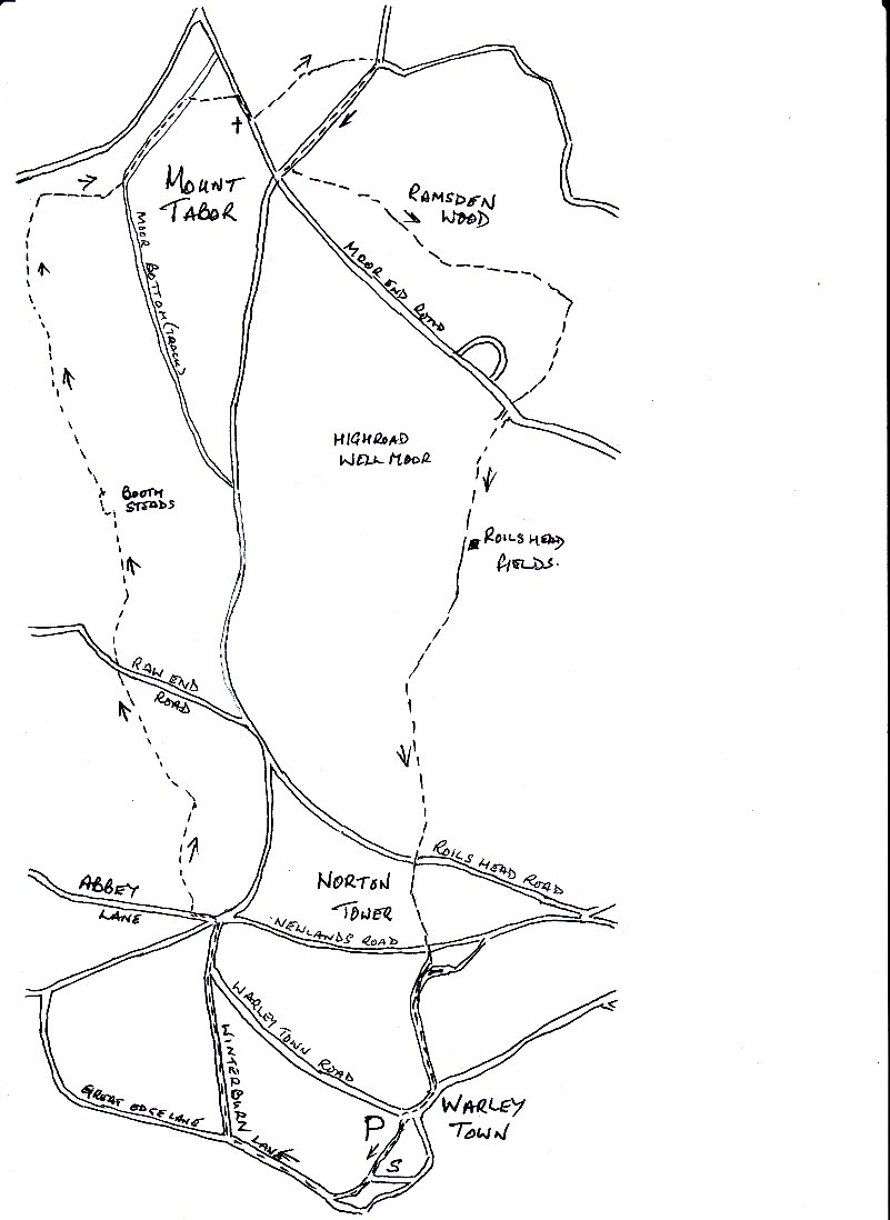
Warley to Ramsden Wood
5 miles – 2.5 hours – grade 2
We start our walk at the village carpark in Warley. Take the track leading between the school and the allotments, as you pass the school keep right and join the Winterburn Lane, continue up the lane, passing the Winterburn PH. At the junction with Great Edge Road, keep right, passing the Vandals Rugby Club and join Warley Town Lane.
Walk to the junction of roads, cross over towards the lodge house and turn left down Abbey Lane. After about 50 meters you will find a style on your right into the field, which will lead you through the hedge onto a walled path. Turn left and follow the path down towards the woodland. Go through the gate on your right, continue up to the tarmac road.
Continue straight forward, you will see a way marker on your left into the field. Walk across the top of the field to a style in the far corner. You will come out onto Raw End Road, cross over and take the track opposite and continue along this track until you come to Booth Steads.
On your left you will find a lift-up style, leading into the field, it is difficult to find a path but in the far right-hand corner, you will see a way-marker, find a path to this. Turn left and walk into the field, the path follows the field top, next to the wall. Keep on the path crossing three fields, you will come to a walled path, cross straight over and continue forward on the path, crossing two more fields, in the right-hand corner you will find a stone style leading into another walled path.
Turn right and follow the path up between the fields to a gated style. The path now goes diagonally left up to the farm track. Turn left and continue along the track. When you have passed the last house on your left, you will see a way marker, opposite you will see a stone style leading onto a stone flagged path towards the houses. Take this path, which will bring you on to Mount Tabor Road.
Turn right and walk down the footpath until you come to the Methodist Church. Opposite you will see a sign ‘Mount Tabor’, cross over the road and take the track at the back of these terraced houses, a sign says, ‘leading to Moor Grove’. At the end of the track you will come to a walled path on your right, which will lead you through the fields and onto Moor End Road, opposite Gibb Lane.
Turn right and follow the footpath back towards Mount Tabor crossroads. Before you reach the crossroads, on your left before the bungalow, you will see a path leading down the field and into Ramsden Wood. Follow the path through the wood, you will come to a service road for the reservoir. Continue along the road until you come to a junction of paths, an old ruin will be on your left, take the righthand path leading back towards the woodland.
You will come to a T junction of paths, turn right and walk up the hill. This soon becomes Buckley Lane and brings you out onto Moor End Road. Go straight forward and up Broadley Road. At the top you will see the walled gap leading into the woodland, continue up the wide path, coming out on to Roils Head. Walk up and pass the building, there are many paths crossing this open moorland but, in the distance, you will see the large building of the former reservoir, follow a path heading towards this. As you walk closer, take the path to your right, towards a children’s play area.
There is a path between the houses which brings you out onto Roil Head Road, opposite is Norton Drive. Cross over and walk along Norton Drive to where the road forks. Straight ahead you will see the bridleway, this leads to Newlands Road. Opposite to your right you will see a wall gap, leading down through the woodland. You will come out to a fork of tracks, take the righthand path down to Edgeholme Lane. Continue down the lane to come out on Stocks Lane. Turn right and follow the footpath back towards the carpark.