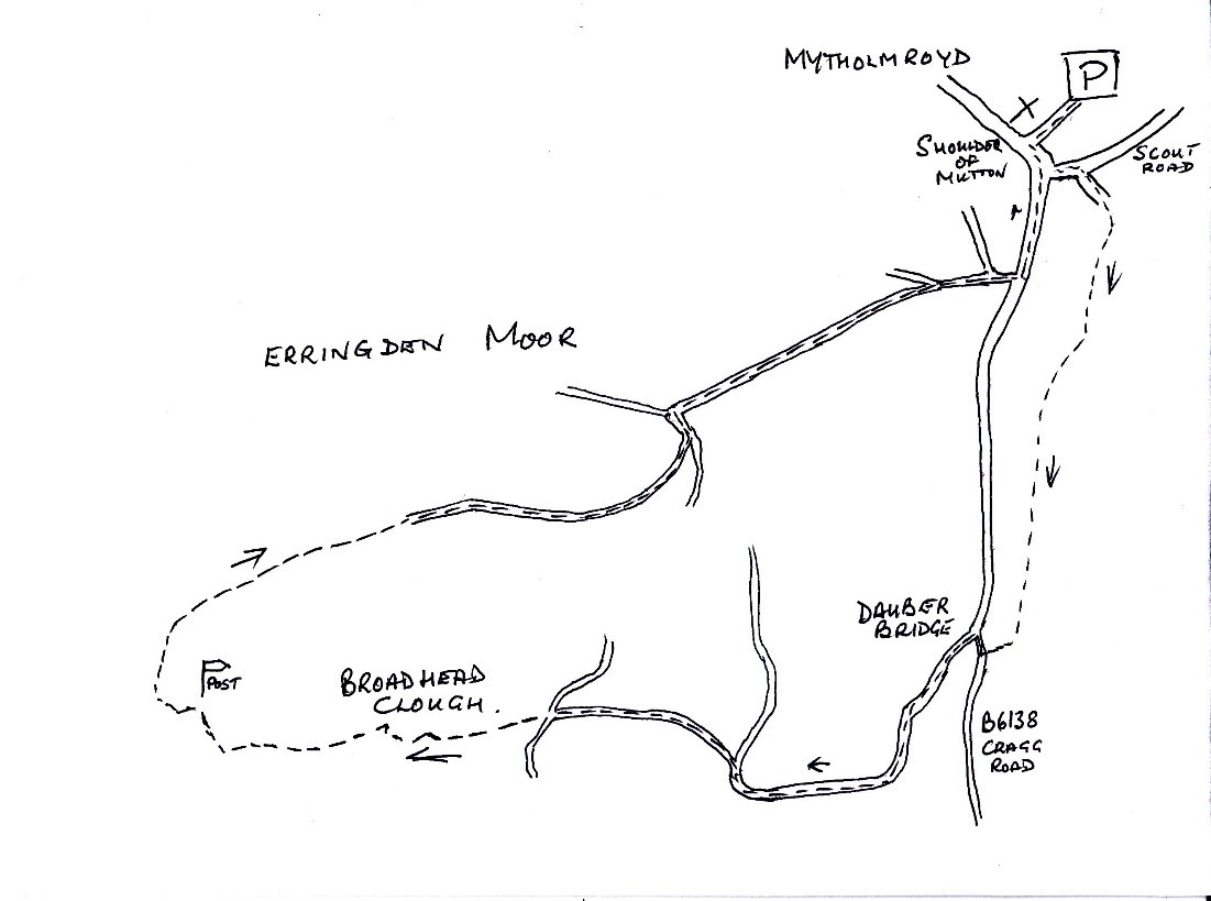
The walk starts from the public carpark opposite
The Shoulder of Mutton on the B6138.
Leave the carpark and turn left, going onto Scout Road. You will see the old chapel, now apartments, go up Hall Bank Road, when the road forks, take the right-hand road onto Stubbings Close. Walk to the end of Stubbings Close and you will see the footpath between two fences. When you enter the woodland, keep to the highest path, you will come out near a tarmac access road, just before is a style on your right taking you on a well-defined path across several fields to gate in the far corner.
Go down the steps, be careful because they come onto Cragg Road, cross over and turn right. Follow the footpath across Dauber Bridge and turn left onto the concrete road.
Continue up the road, at the junction, keep left and follow the road through the fields and across the cattle-grids. There is a gated style at the last cattle-grid, leading onto a dirt crossroads. Go straight forward and enter Broadhead Clough Nature Reserve. The well-defined path takes you up through the clough and can be quite steep in places, there are several flights of steps, take your time, you may need several rests!
When you reach the moor, you will see a signpost in front of you. Over to your left you will Bell House Farm, it was built in the 12th century when Erringden Moor was a deer park, the bell was rung to call the deer for their winter feed. It was also the home of David ‘King’ Hartley of the Cragg Coiners fame.
To your left you will see a way marker, walk to your right and onto the edge of the moor, going due north (if you have a compass) about 30 meters, to a junction of two old walls. The route we want to take follows one of these walls’ half right, in a north easterly direction, on the low side of the moor.
The line of the old wall eventually brings you to a better wall, at the far wall, bear right and follow the old cart track downhill towards the Conifer Plantation. You will see in the far distance Wainhouse Tower, to your left Old Town mill and chimney and as you walk further down, to your left, Hepptonstall Church.
Continue down the wall track to a style before the conifer plantation, follow the path along the field to the far end and take the path to your left down by the trees. As you pass the trees beautiful Calderdale unfolds.
The path becomes steeper as you descend the valley, at a crossroad of paths, continue straight down to the tarmac road – Nest Lane. Turn right and walk along the lane, you will drop down by the Old Fire Station back onto Cragg Road. Turn left and follow the footpath back to The Shoulder of Mutton and the carpark opposite.